|
|

Leyte disaster, background and some clues to upgrade disaster mitigation plansL. Kithsiri Perera, Weathernews Inc,B19-Makuhari Techno Garden, 1-3, Nakase, Mihama-Ku, Chiba-Shi, Japan. Email: Perera@wni.com Takahiko Furuya, Chiba University, Chiba, Japan. Tel: 043-255-8986
AbstractThe landslide disaster that occurred in Leyte Island, the Philippines, last February, killed about 1,100 or nearly all residents in Guinsaugon village. About 500 mm of extensive rains within first two weeks of February became the prime reason for the landslide. Experts say Leyte has a high vulnerability for landslides due to heavy rainfall, geological instability, and forest degradation in mountain slopes. In this research, some background information such as, cloud images, earthquake data, after disaster ASTER satellite image, and land cover information, are analyzed to explain possible gains for the disaster. Furthermore, research emphasizes the importance of finer rainfall observation network in landslide prone areas to upgrade the accuracy of numerical model weather forecasts.1. IntroductionThe Philippines can be considered as one of the most vulnerable countries to hit by natural disasters. According to records, nine big natural disasters occurred in the Philippines with over 1000 fatalities in each case (including 1995 Oct, deaths 995) since 1950. Nearly all well knows causes of natural disasters are taking place in the archipelago through out the year except cold weather related incidents. Especially, the Leyte Island region of central east Philippines is more vulnerable, which receives an average of 19 typhoons annually and heavy monsoon rains (CRED 2006). A massive flood and landslides in 1991 November killed about 6000 people near Ormoc city in northwest Leyte. The latest disaster hit 17th February 2006 and killed about 2000 people in southeast Leyte.
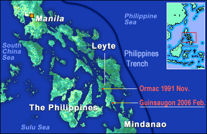 Figure 01. Big landslides occurred in recent years in Leyte Island. Similar to previous disasters, extraordinary heavy rainfall and unstable soil structure of Leyte Island became the prime reason for February disaster too. Figure 01 shows locations of these disasters with some geographical information of the region. After the landslide, experts are stressing the need of an intensive disaster mitigation plan to minimize human losses in future landslides. The present study analyzed some before and after disaster satellite images and data to strengthen this recommendation.
2. Definition of landslideA downward and outward movement of soil mass along the slop forms a landslide (S. THOMSON, 2006). Landslide, mass wasting, mass movement, and slope movement, have defined under same broad meaning by scholars, but the term landslide is universally accepted in many situations to explain soil movements (Crosier, M. J. 1986). When a landslide triggered by heavy rains in a steep slope area, soil and mudflow can move 30m/s, causing a disastrous impact on the moving path. But, scientists consider landslides as one of the most predictable geological hazards (USGS, 2006) (GCRIO, 2006). Leyte Island is notorious for having active landslides (areas with frequent soil movements or which had recent movements) due to a combination of favorable geological and meteorological factors to occur them.
3. The role of precipitationWhen a landslide occurs, the weight of soil mass gains an extra weight under natural conditions. Here, precipitation plays the main role to add the extra weight. Other common factors to cause a landslide are; soil movements caused by previous times, erosion, volcanic materials, changes in vegetation cover, changes in infiltration process, and variations in atmospheric pressure. Many researchers have clearly documented the strong relationship between landslides and rainfall. One of recent studies in this field founded when the total rainfall of monsoon season exceeds 840mm, possibility to occur landslide in Annapura Range of Himalayas, Nepal, is very high (Gabet et al, 2004). The Leyte disaster further showed, not only the amount, but also the micro level special intensity of the rainfall is an important fact to consider.The archipelago of Philippines has a tropical maritime climate with huge variations in average annual rainfall from 914 mm (General Santos, Cotabato) to 4358 mm (in Borongan, Samar). This is due to the fact that the country exposes to the Southwest monsoon, Northeast monsoon, North Pacific Trades, Intertropical Convergence Zone, tail end of the cold front, easterly waves, the passage of tropical cyclones and the El Nino Southern Oscillation (ENSO) phenomenon (GCRIO, 2006). Hence, rainfall related natural disasters are common throughout the year in Philippines. Rainfall patterns in east and west regions of Leyte Island have significant differences, though the entire Island gets a high amount of rainfall. The eastern region, where the latest landslide occurred, gets over 2000mm of average annual rainfall. Also, the rainfall amount is changing significantly from place to place, according to wind movements and elevation differences of central Philippines. Figure 02 presents a series of cloud images acquired from GMS satellite. Each image represents 0500 UTC cloud cover of each day. Here, it is clear that disaster-hit area had very thick clouds as early as 10 days before the landslide. The cloud cover is relatively thin and scattered just before the incident but small cloud formations can be seen all over the region prior to the disaster.
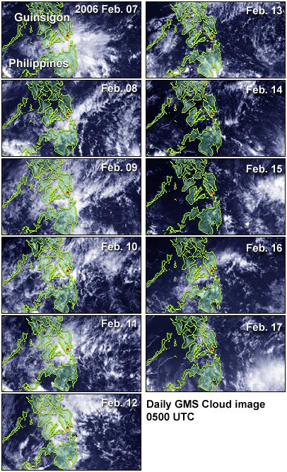 Figure 02. Cloud cover over the Philippines, from February 7 to 17th. Rainfall from these small clouds is affecting to the accuracy of numerical models according to the spatial resolution of the model. The special resolution of numerical models becomes an important factor to decide the comprehensive feature of the forecast. The Philippines meteorological service (PAGASA) uses 20km mesh (for micro level phenomenon) and 60km mesh (for mesoscale phenomena like typhoons) based MM5 (PSU/NCAR mesoscale model) rainfall model to issue daily weather forecast (PAGASA, 2006). MM5 has been developed to simulate or predict mesoscale atmospheric circulation (UCAR, 2006). This moderate resolution may leads to coarse accuracy of the weather forecast for small area and result may affect to disaster mitigation plans. According to field observation, landslide-hit region received 500mm of rainfall within the period of 1st February to 17th February. The Philippines weather service says that this amount is nearly equal to five times of the normal amount for that time period. The heavy rain was caused by La Nińa weather phenomenon in the Pacific Ocean. Ground rainfall figures are tally with the satellite data based rainfall estimations. Figure 03 shows the TRMM-based, near-real time Multi-satellite Precipitation Analysis (MPA) produced by NASA over the disaster hit region (TRMM Map 2006). The total rainfall from 4th February to 17th is presented here. According to coarse resolution of these data, heavy rainfall at the exact location is not clearly visible. Furthermore, PAGASA (government meteorological service) has identified the development of weak La Nińa episode from November last year. PAGASA had declared that this weather phenomenon might cause an above average rainfall condition over the country, up to May 2006 (PAGASA). These evidences show, Leyte Island had heavy rainfall as expected by weather services, but not clearly received forecast of the amounts of rainfall to each local area, due to lack of intensive observation network in the field.
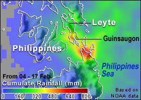 Figure 03. TRMM satellite data based rainfall total.
4. GeographyGeologically, Leyte Island region is located just west to a tectonic plate boundary. Intense fracturing and weathering have created an unstable soil structure in Leyte Island, which is highly vulnerable for landslides (DNER, The Philippines, 2006). The Philippines government geologists have identified 82.6% of the Leyte as prone to landslides in 2003 and ranked as fifth-most susceptible province of the country. This geologically weak background is further weakened by the high occurrence of earthquakes. From January to February 17th 2006, there were 12 earthquakes around Leyte with over 3.0 magnitude of power (see figure 04). The last moderate quake hit in February 17th, with 4.3 magnitude according to the USGS earthquake data archive (USGS, earthquake data, 2006). According to the Philippine institute of Volcanology and Seismology, the same quake recorded as a 2.6 magnitude earthquake and hit Leyte nine minutes before (10.36 am local time) the disaster. With highly saturated soil with water after two weeks of heavy rains, even a small earthquake can trigger a mass movement.
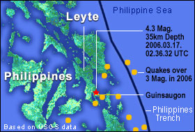 Figure 04. Recent earthquakes around Landslide site (USGS, earthquake data, 2006) Traditionally, authorities blame the logging or deforestation in mountain slopes for acceleration of landslides. According to the department of environment and natural resources, the Philippines, (DENR, 2006), about 50% of the population (1.17 million people) in Leyte and Samar region has encroached into forestlands for farming. Some forest areas have largely replaced by coconut plantations. Even well before the February disaster, DENR officers have pointed out the severe forest degradation of Leyte Island. Its 59% forest cover in 1900 has reduced to 12% by 1987 (Indymedia, 2003). Land cover changes are altering the water cycle of mountain slopes. This may have contributed in a negative way to the landslide, apart from the other main causes; i.e.; very intensive rain received within a short period, possible impact of earthquakes, and the geological background of the area. Generally, land cover changes are altering the evaporation, infiltration, and runoff water and micro-changes of mass movement process.
5. Landslide disasterWith the severe rainfall, the killer landslide occurred on 17th February 2006 and buried Guinsaugon village with nearly all inhabitants of the area. According to Philippines department of environment and natural resources, Leyte landslide buried about 1000hs of land under a thick mud layer. Heavy rains continued even after few days from the landslide, and clear satellite images (visual band images) were not possible acquired due to the cloud cover. After about 10 days, Advanced Spaceborne Thermal Emission and Reflection Radiometer (ASTER) on NASA’s Terra satellite successfully observed the disaster recording a cloud free image. Figure 5 shows color enhanced ASTER image of March 01, which shows the huge mudflow clearly (NASA 2006). Contour lines of 700m and 100m are overlapped with the image. Within less than 2km of distance, elevation decreases from 700m to 100m in the affected area, which was the reason to bring muddy soil within a short time to the village. When the mudflow had moved into relatively flat river basin, it fanned out over a large area.
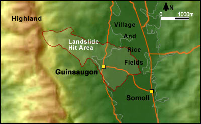 Figure 05. ASTER image (color enhanced) of landslide (NASA,2006)
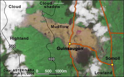 Figure 06. Analysis of landslide hit area on pre-disaster SPOT image The UNISAT published (UNISAT 2006) a set of images of Leyte landslide. Figure 06 shows a section of one of those images, a detailed analysis of high-resolution SPOT image acquired on 1st June 2003. The image presents a close up of the village of Guinsaugon and the extent of landslide derived from satellite imagery (ALOS, RADARSAT-1 and ENVISAT ASAR). We have further visually interpreted the image to identify some land cover features to emphasize less vegetated regions on upper region of the mountains (see less vegetation region marked by green line and water flowing direction by purple color arrows). Intensive rainfall was the prime reason, but poor land cover on mountains and steep slopes must also have contributed to the occurrence and speeding up of the landslide. Land cover information in these pre-disaster images will help to organize disaster mitigation and community relocation plans in Leyte.
6. Disaster mitigationWhen examine the causes for Leyte landslide, the prominent role of the heavy rainfall is evident. Therefore, disaster mitigation plans in Leyte must be based on an improved rainfall data collection and weather forecasting process. One of the urgent requirements is the installation of real-time data retrieving rain gauges at a closer range in landslide vulnerable areas. The density of these rain gauges must be decided on the geophysical background of the area, which includes rainfall type, rainfall intensity, river and streamline network of the area, earthquake vulnerability, slope, soil, land cover, and human settlements. With a more intensive rainfall data collecting network, present 20km mesh of Philippines can be refined, at least for the central-east region of the country, which faces a large number of typhoons annually. Some developed countries like Japan are presently conducting research to build 1km mesh weather simulators.According to the department of Environment and Natural Resources of Philippines, there are large amount of identified landslide prone regions in the country. Presently, the government is producing a detailed hazard region map of the country. This information must be combined with a finer resolution rainfall modeling system. An extra care must be given to protect the vegetation cover on hill slopes, by educating villagers about the importance of vegetation cover and soil conservation. Apart from technological advancements, villagers in vulnerable areas must be relocated or trained to evacuate within a short notice from danger zones. An extensive disaster vigilant system in landslide vulnerable area is another approach to minimize the damage.
References; CRED 2006, Center for Research on the Epidemiology of Disasters, Université Catholique de Louvain , Brussels, Belgium, http://www.cred.be/ Crozier, M. J. 1986, Landslides Causes, Consequences, and Environment CSRIO, 2006, Climate of the Philippines, http://www.cossa.csiro.au/reports/campbells/bkk/philrp.htm DENR, 2006, Department of Environment and Natural Resources, the Philippines http://www.denr.gov.ph/article/articleview/3597/1/39/ Earthquake data, USGS, 2006, http://neic.usgs.gov/neis/epic/epic.html Gabet J. E., Burbank D. W., Putkonen J. K., Pratt-Sitaula B. A., Ojha T., Rainfall threashold for landslide in the Himalayas of Nepal, 2004, Gemophology 63 (2004) pp 131-143 GCRIO, 2006, Slope failure (landslide) information http://www.gcrio.org/geo/slope.html Indymedia, Dec. 2003, Forest degradation of Leyte, http://qc.indymedia.org/news/2003/12/15.php NASA 2006: ASTER Satellite image, http://earthobservatory.nasa.gov/NaturalHazards/natural_hazards_v2.php3?img_id=13386 PAGASA, 2006, Numerical weather prediction model Info. http://www.pagasa.dost.gov.ph/ Thomson, S. (2006), Definition of Landslide, http://www.thecanadianencyclopedia.com/ TRMM Map 2006: Earth observatory, NASA, http://earthobservatory.nasa.gov/NaturalHazards/shownh.php3?img_id=13374 UCAR(University Corporation for Atmospheric Research), March 2006, http://www.mmm.ucar.edu/mm5/mm5-home.html UNISAT satellite imagery 2006, http://unosat.web.cern.ch/unosat/ USGS, 2006, Earthquake data, http://neic.usgs.gov/neis/epic/epic.html USGS, 2006, Landslide information, http://landslides.usgs.gov/learningeducation/ls101.php |