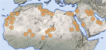
Maps and Graphics  Land cover |
Latest Environmental Content
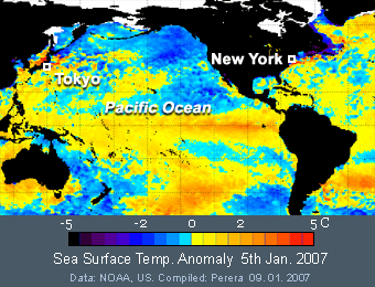
High sea surface temperature (SST), which makes El Nino (means The Child in Peru) becomes more effective once in every 2 to 7 years. During this extreme temperature episode, global air pressure and wind circulation are affected. As you can see in this SST image, very high temperature anomaly can see in New York and Tokyo area. According to ground temperature readings, both regions are recording well above the average in last week. Due to the warm winter, oil price also has decreased considerably. Same weather conditions are prevailing in north and northwest Europe and northeast China and Korea too. But contrast to this, generally hot summer in northeast Australia is experiencing relatively mild summer (see huge blue sea area east to Australia).
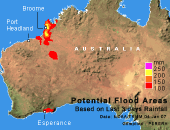
While devastating drought damages rest of the country, heavy stormy rains in past few days triggered flood fear in southwestern and some northwestern Australia. According to the Bureau of Meteorology, Esperance region in southwest received 155mm of rainfall within last 24 hours by the strongest summer storm in the region in last 30 years. Authorities are advising people to avoid lowland roads, and also for possible relocations of livestock. The maps shows flood potential calculated by NOAA using satellite based rainfall readings. Broome city and vicinity in northwest received heavy rains from cyclone Isabel, which hit the area few days ago. Today’s weather is mostly sunny in western Australia, except northern coastal area.
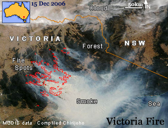
Drought in Australia is continuing, while firefighters are battling with bushfires. Victoria state is severely affected by huge bushfires where over 19 houses destroyed in last few days. This MODIS satellite image shows yesterday's morning conditions of the fire. About 100km wide giant smoke column is moving southeast direction from Gippsland region, Victoria. Red lines show identified fire spots by the satellite. State government already declared assistance for people those who lost properties from fire. Despite today's low wind, dry sunny weather over the region in next few days will keep firefighters busy. So far, one death has reported related to fire.
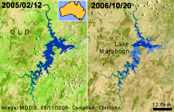
The worst drought hit Australia in last 100 years has critical affected to the agricultural products of the country. Government already declared more than 70,000 farmers are eligible for drought assistances. Much of the farming and ranching belt in south and south east of the country, has been hit hard. A severe water restriction is undergoing in populated regions in east and north. These satellite images of 2005 and 2006 shows Baraboon Lake in southeast Queensland. Fist image shows greener environment after last year summer storms, while 2006 image shows present dry vegetation and shallow water level (light blue) is the lake.
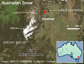
Snowy mountains in southeast New South Wales, Australia, has a huge attraction due to its very limited snow cover. This is the only location that people can ski in Australia, other than Tasmania. When the spring arrives, the small snow patch is melting rapidly. This today’s MODIS satellite image shows remaining snow over Snowy Mountains. As the image shows, about 25km long and 20 km wide snow area is still remaining over the higher areas of the mountain. The area has Australia’s highest mountain Mt. Kosciusko (2228m) and few more peaks over 2000m.
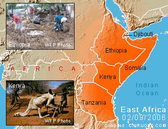
Millions of people in East African countries are struggling with disastrous weather extremes, drought and flood. Ethiopia, Somalia, Kenya, Tanzania, and Djibouti, suffered severely by the long drought in for many years (see the map). Even hard animals like camels were killed by the drought (see the photo from Kenya). But, since July 2006, heavy rains brought floods to the region killing over 1000 people so far. The upper photo shows people are searching valuables after the killer flash floods occurred in Ethiopia last month. Uncertain weather is the main enemy for poor African countries.
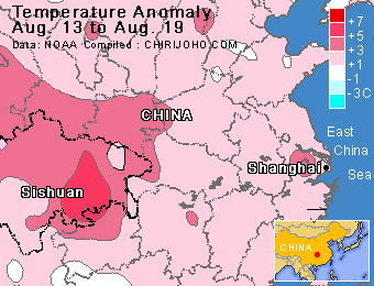
The worst drought in last 50 years is beating southwestern China. Report says already about 5 million tons of grains have lost to the drought in Sichuan province. Government says about 2 million hectares of cropland have damaged and nearly 10 million people are facing severe restrictions of drinking water. Soaring summer temperature is further hardened the drought. In last week temperature anomaly map, drought hit Sichuan province shows high deviation from the average temperature (red color area), which was the trend for last 8 weeks.
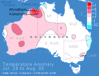
Most of the countries in northern hemisphere are battling with summer heat. But in Australia, while having the winter, some areas are recording summer like temperature. Especially, northern coastal city Wyndham in Western Australia recorded 32C today. This area had over average temperature for last five weeks while rest of the country has near average values. Map shows last week temperature anomaly. Wyndham is the most northerly city of Western Australia and famous for giant salt-water crocodiles.
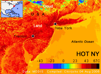
Record breaking hot weather blanketed the East and Midwest of the USA, killing about 24 people so far in this summer. New York city recorded 37.7C yesterday, and similar high readings came from surrounding area. High humidity in Virginia sent the temperature to feel as high as 44C. The MODIS LST (Land Surface Temperature) satellite image of yesterday noon shows hot New York City and surrounding area. Compare dark red area (40C) and lighter colors in the sea and cloud. But, a cold front move to the region since yesterday, bringing a relief to millions of affected people.
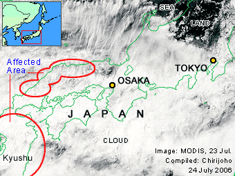
Extraordinary heavy rains in southern to central region of Japan killed over 25 people within past few days. Some locations in Kyushu Island received more than 1000mm of precipitation within last four days. Thousands have evacuated due to risk from more floods and landslides. Japan’s weak soil structure is highly vulnerable for landslides in heavy rainy season. The yesterday’s image here shows heavy rain clouds over Japan. Meanwhile, rains have caused widespread destruction in North Korea. Report says hundreds have killed or gone missing in floods. In further south, typhoon Kaemi is pouring torrents on Taiwan, while moving into southeast China direction.
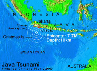
A magnitude 7.7 earthquake triggered killer tsunami, destroying number of villages in southern Java. Few weeks ago, a disastrous earthquake killed over 5,800 people in Java, but the island was spared by 2004 tsunami. The latest earthquake hit about 360km south to Jakarta and reports say over 300 people have killed around and area northwest to Cilacap city. Since a number of popular beach resorts were hit, fatalities among foreign tourists can be expected. Tsunami hit after about 1h from the yesterday’s quake, but people were not evacuated due to lack of a proper warning system. Australia’s Christmas Island is also located close to the quake center, but no significant damage was occurred. Indonesian islands are located in one of the most vulnerable regions to occur earthquakes.
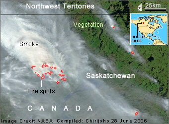
Early summer forest fires are burning large areas in central Canada. This June 26th MODIS image shows a huge fire raging in northern Saskatchewan district. According to image scale, smoke column of the main fire spot is wider about 30km. Only a small area is included in the image, but fires have spread within a vast region of central Canada. According to Canadian weather information, nearly all areas of Saskatchewan province are now having high fire vulnerably. Central Canada has high temperature values today, between 25 to 30C, encouraging more fires. Forest fires can be ignited by lightning and then spread to destroy large forest patches. This natural incident was not a significant environmental threat in the history till forest clearance started for commercial needs since last 200 years.
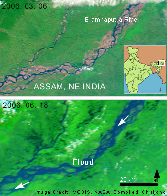
Heavy monsoon rains have triggered devastating floods in northeast India. Floods and landslides from monsoon rain annually hit Assam district and surrounding low laying areas. After strong rains in last week, this year floods have started and killed over 17 people and displaced more than 1.5 million people. Rainfall for the week ended by 17th June recorded more than the total rainfall measured in May for central and southern Assam. Now the floods are spreading into northern Bangladesh and to the west of Assam. The image shows swelled Bramhaputra River with monsoon rainwater. Compare the lower image (18 June) with March image, which has the average water level of the river. As more rains are expecting sooner relief from flood cannot be expected.
|
|