|
|

The role of MODIS data in visualizing flood disaster information for Mass MediaL. Kithsiri Perera, Weathernews Inc,B19-Makuhari Techno Garden, 1-3, Nakase, Mihama-Ku, Chiba-Shi, Japan. Email: Perera@wni.com Assela Pathirana, Public Works Research Institute, 1-6, Minamihara, Tsukuba-shi, Ibaraki-ken, 305-8516 Japan. Email: pathira@pwri.go.jp
Concluding remarksThrough the freely available and easy to navigate MODIS image sites offered by NASA, use of MODIS images are becoming increasingly popular. Recent developments in personal computer, low cost software, and high-speed Internet connections have built the infrastructure for this popularity. We have described the importance of visualizing flood disaster information using MODIS images, for the use of mass media. Even without any other information sources, only visual interpretation of flood time image on the PC can produce a significant amount of information. The first image (initial flood content image) can be developed into series of images, by adding more MODIS images and available GIS data. Elements like, pixel size of the flood content graphic, type of the graphic file, and size of the file (in kilobyte) are depending on the respective mass media portal. By comparing previous disastrous flood season images with present flood contents, rough damage estimations can be made for prevailing flood. Bringing flood disaster information to global news media will help to attract wider attention for similar disasters, which can be a boost to organize effective relief and flood mitigation activities. Also, readers will get fresh information with easy to understand image contents about changing environment.
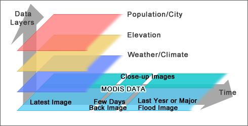 Figure 03. TRMM satellite data based rainfall total.
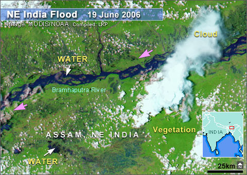 Figure 07. Floods in northeast India monitored by MODIS 250m data. (FULL REPORT WILL ADD SOON) References; Dartmouth University flood observation data, 2006, http://www.dartmouth.edu/~floods/Alertindex.html DEM data of Northeast India and Bangladesh, 2006, http://edc.usgs.gov/products/elevation/gtopo30/gtopo30.html Low J., Liew S. C., Kwoh L. K., 2006, AARS proceedings, Automated Near-Real-time Flood Detection and Mapping Using Terra Modis, http://www.gisdevelopment.net/aars/acrs/2004/b_change/acrs2004_b2001pf.htm Low J., Liew S. C., Kwoh L. K., 2006, Environmental Monitoring of Southeast Asia using MODIS Direct Broadcast Data, CRISP, National University of Singapore. http://www.isprs.org/publications/related/ISRSE/html/papers/784.pdf MODIS limitations, 2006 http://nsidc.org/data/modis/faq.html#2 MODIS main wed site, 2006, http://modis.gsfc.nasa.gov/ MODIS Orbit Information 2006, http://www.ssec.wisc.edu/datacenter/terra/ MODIS subsets, 2006, http://rapidfire.sci.gsfc.nasa.gov/subsets/ Perera, L. K., Tateishi, R., 2001, A GIS Approach to Identify Highly Vulnerable Zones for Flood Disasters in Asia, Proceedings of annual symposium of the Japan Society of Photogrammetry and Remote Sensing, May, 2001, Chiba University, Japan. Rainwaterharvesting.org, Rainfall data of India, 2006, http://www.rainwaterharvesting.org/Urban/Rainfall.htm Sciencedaily.com, News article, 13 Oct 2000, http://www.sciencedaily.com/releases/2000/10/001013074357.htm UMCOR archive, 2006, Flood photo of Mozambique http://gbgm-umc.org/umcor/00/mozphotos.stm Visibleearth, 2006, A Comparison of MODIS with AVHRR, http://visibleearth.nasa.gov/view_rec.php?id=10117 Wikipedia, 2006, Flood disaster Information, http://en.wikipedia.org/wiki/List_of_deadliest_natural_disasters |