

Tsunami disaster of Sri Lanka, its uniqueness, affect, and
some damage mitigation possibilities
L. Kithsiri Perera, Weathernews Inc,
B19-Makuhari Techno Garden, 1-3, Nakase, Mihama-Ku, Chiba-Shi, Japan.
Email: Perera@wni.com
1. Introduction
Sri Lanka was the first country that was contacted by the US tsunami-warning center, Hawaii, when the tsunami was devastating the coastal areas of Indian Ocean (WEB ref. 01). But, due to lack of well-coordinated communication among countries, Sri Lanka, India, or even Sudan (Northeast Africa) did not receive tsunami warning with enough time to take necessary action (WEB ref. 02.) On the other hand, there was no well-established natural disaster warning system in these countries. Also these countries have had no disastrous tsunami in living memories. December 26th, 2005 tsunami caused a massive damage and killed tens of thousands of people and opened new research fields to conduct studies in tsunami risk mitigation. This article describes some early observations of tsunami damage using field photographs, satellite images, and digital maps of the affected area, focusing on the conditions of Sri Lanka.
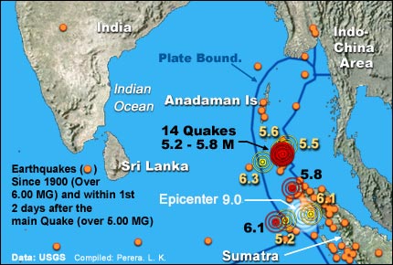 Figure 01. Sri Lanka is away from quake prone regions (WEB ref. 03)
2. The tsunami damage map of Sri Lanka
Since the occurrence of tsunami, dozens of studies have been conducted regarding the physical damage and social impacts caused by the event. Sri Lanka had never faced a similar scale natural disaster in its known history. Almost 60% of the Island's coastal area hit by the disaster and hundreds of villages along the coast were severely affected. To get a general idea of the overall damage, some of the available data in WEB pages, field information collected by conducting a ground survey, and, other various geographical data were combined to produce the damage region map presented in Figure 2. Damage area marked approximately within the coastal area from 0m to 100m (elevation) in yellow. Hence, width of the area depends on the elevation. The damage area in this figure is not verified by secondary extensive field investigation and should be used for primary level studies only.
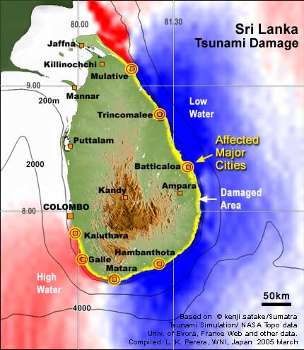 Figure 02. Damaged area and calculated tsunami wave movements
(Data sources: WEB ref. 4, Web ref. 05, WEB ref. 06, and WEB ref. 07).
	Figure 02. Damaged area and calculated tsunami wave movements
	(Data sources: WEB ref. 4, Web ref. 05, WEB ref. 06, and WEB ref. 07).
3. How tsunami hit Sri Lanka
Generally, tsunami waves move from the earthquake epicenter according to the structural shape of the geological plate movement occurred during the earthquake. But, these wave movements are further adjusted during the journey due to the bathymetry of respective sea or ocean. In the December tsunami, devastating impact to Sri Lanka occurred due to the sudden rise of landmass of the island in the vast empty ocean from Sumatra (see bathymetry values in Figure 2). Mathematical models and field investigations show that tsunami hit Sri Lanka after 2 hours of its generation (WEB ref. 06). Also, the impact and the direction of waves were varied from place to place. According to a statistical model produced by Disaster Control Research Center of Tohoku University, Japan, southern city of Sri Lanka, Galle recorded slightly higher than 2 m waves but Yala (southeast cornet of the island), hit by about 6 m high waves (WEB ref. 08). Another research team from Japan, conducted intensive field investigation February and found that 11.3m high tsunami waves hit Yala coast of southeast Sri Lanka (WEB ref. 09), few meters higher than the initial mathematical models calculated. Similar filed investigation results found in Thailand by a research team from University of Tokyo. In that study, investigators found that about 10m high tsunami waves had hit in Kao Lak beach of West Side of Phuket Island (WEB ref.10)
Mathematical models also show that the tsunami first hit the southeastern corner of the Island, and then moved along the eastern beach, and the southern and southwestern beach (WEB ref. 06, animation). Satellite images and field damage reports from southwestern Sri Lanka (from Matara to Kalutara) confirm this southwestward turned tsunami waves. However, the tsunami did not reach Colombo region just 40 km north from Kalutara (see Figure 2), which has highest population density in Sri Lanka and the concentration of most important economic activities.
4. Features of the damage pattern
The tsunami came to Sri Lanka with a total surprise. Even after the first segment of waves hit eastern Sri Lanka, no warning reached from the east to southern coastal areas for evacuation, although the tsunami took some time to reach the southwestern coast. On the other hand, Coastal village houses were constructed according to individual needs and economic limitations, but not to withstand a tsunami hit. When considered the land use of coastal Sri Lanka, it's easy to understand that the types of trees are mainly depending on the annual rainfall. Hence, coast of southwestern Sri Lanka has more perennial trees with many coconut (Cocos nucifera) trees. But, eastern to northeastern coastal areas have less coconut trees, where land is less productive. Also, geographically, eastern to northeastern coast has many areas with flat land, thus the advancing tsunami easily overtook the villages considerably far from the beachfront. Analysis of satellite image shows some features of these damaged areas. Damaged area is different from place to place even though the elevation is almost same (see Figure 3). As visible in the field photograph (Figure 3, lower photograph), coconut trees right next to the beach are standing after the massive hit of the tsunami, while many other trees and man made structures have been destroyed.
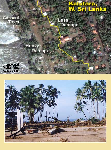 Figure 03. Amount of damaged is different even in the same elevation region, due to local land
cover pattern and building strength. The lower photograph shows a survived coconut trees,
just few meters away from the beach.
	Figure 03. Amount of damaged is different even in the same elevation region, due to local land
	cover pattern and building strength. The lower photograph shows a survived coconut trees,
	just few meters away from the beach.
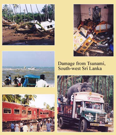 Figure 04. Field photographs from southwestern Sri Lanka. Upper and center photographs show
destroyed buildings and the railway line. Due to weak sandy coastal soil layers and the
massive force of the tsunami, railway line was washed away. Iron and concrete structures of
some buildings could withstand the massive force of tsunami (lower two photographs).
	Figure 04. Field photographs from southwestern Sri Lanka. Upper and center photographs show
	destroyed buildings and the railway line. Due to weak sandy coastal soil layers and the
	massive force of the tsunami, railway line was washed away. Iron and concrete structures of
	some buildings could withstand the massive force of tsunami (lower two photographs).
5. Human reactions to the disaster
The Sumatra tsunami was the first such biggest disaster to hit Sri Lanka in its known history. Most Sri Lankans had never heard of the word tsunami before and could not imagine sea waves moving inland with such a mighty force. The low and high tide seawater movement is also negligible in Sri Lankan beaches. Figure 5 (field photographs) shows, damaged houses and vehicles. According to eyewitness record, people even walked into seawater to call back their fellow people and boats (see center-left photograph in Figure 5), after the first hit of the wave. The tsunami also destroyed a train and killed about a 1000 passengers. According to survived witness records, after the train was hit by the first wave, people remained in the train, due to lack of knowledge about the behavior of a tsunami. People had waited inside the train without evacuating, till the second wave hit the train, killing hundreds of people (in Figure 5, see the damaged train).
6. Sustainable disaster mitigation
After the December great earthquake, seismic activities increased in northwestern Sumatra region converted Sri Lanka into a highly vulnerable target for tsunamis. Since last December, dozens of moderate quakes occurred in Sumatra and Andaman Sea region. The latest quake hit Nicobar Islands in Andaman Sea, on 24th of July with 7.2 magnitudes of power (WEB ref. 03). Since there is no way to avoid or predict earthquakes and tsunamis, it is important to consider how to cope with the similar disasters in future.
As soon as after the tsunami disaster, Sri Lankan villages have been re-organized under temples, mosques, and other local organizations before the government started to relocate the affected families. In some situations, people depended on traditional ways to clear the damage areas by using elephants (Figure 5, photographs) and volunteer work forces. Elephants are easy to use in rough terrains, where other machinery cannot be moved easily. It is important to take a note of the initial reactions of people to the disaster and there is a need for creating awareness among the people.
There is also a need to carefully consider the post-disaster land use planning in disaster-hit areas. The government of Sri Lanka is considering implementation of 100 to 200 meter buffer zone to be left free from human activities to minimize damage from future tsunamis. But, it is important to consider the width of the buffer zone, according to the features of previous damage and local geography. Also, most importantly, coconut trees must be protected in the beachfront and must be replanted as much as possible. Few lines of coconut trees prove to have two-way benefits, as a natural protector and also as an economically valuable crop. Finally, in order to rebuild the damaged areas, it is necessary to get the large-scale economic aid from other countries. But, when implemented the rehabilitation and reconstruction plans, it is important to protect traditional local village economic activities in order to sustain re-building plans in the long run.
Figure 05. The devastation caused by the tsunami can be seen in the upper two photographs. Some people rushed into the sea, after the first wave, without knowing the danger of secondary tsunami waves (center-left photograph). The destroyed train is shown in center-right photograph. An elephant was being transported to a damaged area for clearing work.
References;
WEB ref. 01   http://www.prh.noaa.gov/ptwc/ Pacific tsunami cent
WEB ref. 02. http://globalresearch.ca/articles/CHO501A.html. (Why the warning late?)
WEB ref. 03. http://www.usgs.gov (Data for fig. 01 map)
WEB ref. 04. http://digitalglobe.com/ (Satellite Image)
WEB ref. 05. http://polarbear.css.cornell.edu/srilanka/default.asp (Data for damage area map)
WEB ref. 06. http://staff.aist.go.jp/kenji.satake/Sumatra-E.html (Tsunami simulation)
WEB ref. 07.
http://www2.jpl.nasa.gov/srtm/srilanka.htm#PIA06670 (NASA topographic data for damage area map)
WEB ref. 08.
http://www.tsunami.civil.tohoku.ac.jp/hokusai2/topics/04sumatra/index.html
WEB ref. 09.
http://www.drs.dpri.kyoto-u.ac.jp/sumatra/srilanka-ut/SriLanka_UTeng.html#period
WEB ref. 10.
http://www.drs.dpri.kyoto-u.ac.jp/sumatra/thailand/phuket_survey_e.html, (Research Center for Disaster Reduction


TOP / HOME
Please send your comments to perera@chirijoho.com
Copyright (c) 2005, All rights reserved.
|