|
In Japanese: Chirijoho I maintain this site to post contents of natural disasters, incidents of environmental changes, and significant images of the earth and space. Also, some of my research papers and maps are included here. Please send your comments. - L. K. Perera |
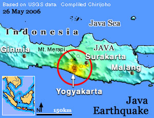
Java Erathquake
A devastating earthquake flattened a densely populated region of Java Island, Indonesia, killing about 6,000 people. Magnitude 6.3 quake hit about 17 km below the sea level, on 26th of Friday. Map shows the disaster hit region and color indicates the intensity and damage level. Red represents highest damage level and light green and white shows no damage areas. Over 130,000 houses damaged in five districts of quake hit Yogyakarta province and hospitals became overcrowded with tens of thousands of injured people. The deadly volcano, Mt Merapi (2,968m) is located just 60 km north to the quake hit area and shows a clear increase of activities. Geologists are watching the developments of the volcano irruption due to more than 850 aftershocks recorded since the quake.
|