


Geographic Information
In Japanese: Chirijoho
I maintain this site to post contents of natural disasters, incidents of environmental changes, and significant images of the earth and space. Also, some of my research papers and maps are included here. Please send your comments. - L. K. Perera
|
|
 |
|
Maps and Graphics
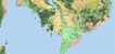
Land cover
| Land cover maps of Mekong River Basin (original data set is at 250m resolution, a study under the UN University, Tokyo) and Asia Land cover mapping project conducted with Chiba University, Japan, are included.
|
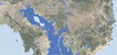
Flood
|
Land cover and flood inundation map of Mekong River Basin (original data set is at 250m resolution, a study under the UN University, Tokyo). Also, some data related to floods in Asia are included.
|
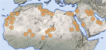
Sandstorm
|
Maps from a detailed study on sandstorm (or dust storm) in Bodele Depression, Sahara and sandstorm originating locations of Asia and Africa are included.
|
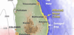
Tsunami damage
|
Maps and graphics of Tsunami disaster of Sri Lanka. More data are included in the research paper section.
|
|